Plan Framework
Mobility
The map below highlights the Mobility Framework identified for the Texas A&M-San Antonio Area Regional Center. Scroll down to learn more about the vision for Mobility in the Plan Area.
To provide specific feedback on the map, please click and drag a box on that location of the map and fill out the comment box. We would love to hear more from you!
You can also visit the bottom of the page to leave additional feedback.
Background and Transportation Vision
In 2016 the City of San Antonio adopted the SA Tomorrow Multimodal Transportation Plan, to make our city’s transportation system “sustainable, safe, convenient, efficient, and inclusive of all modes.” The plan adopted by City Council established “a shift in focus from moving vehicles to moving people,” in order to manage traffic congestion and improve transportation choices. The plan identified two primary and interdependent methods for managing future traffic congestion:
- Develop a land use pattern and policy to promote local trips
- Provide transportation options in addition to vehicles that connect Regional Centers
SA Tomorrow Multimodal Transportation Plan acknowledged that we cannot build our way out of congestion, and that the Comprehensive Plan, and associated land use plans, are a primary opportunity to improve mobility in San Antonio. By welcoming more people to live, work, and play in urban centers, regional centers, and transit corridors, we can shorten trip lengths, offer more transportation choices, and improve quality of life.
The combined costs of housing and transportation (commonly referred to as H+T) are often a large portion of a household’s budget, with experts recommending the combined total not be more than 45% of household income. In the Greater San Antonio Region that total on average is 53%. Walkable communities that provide great transit options can reduce the household transportation costs for the average person, because if people have an alternative to driving alone, transportation costs can be stable even when gas prices rise. By providing transportation options, as some people choose to go to their destination on foot, bicycle or transit, the number of cars on the road will be minimized, reducing traffic delay for those people that choose to drive.
The Texas A&M-San Antonio Area Regional Center, named after the largest educational institution in the plan area, Texas A&M University-San Antonio, is a major educational and industrial hub in the city. In combination with Toyota Motor Manufacturing Texas (TMMTX), these two major institutions influence surrounding industrial, institutional, rural and agricultural districts south of the plan area. In the process of expanding to accommodate an estimated 50,000 students, Texas A&M University-San Antonio will require extensive critical infrastructure and investment in a variety of transportation options that enhance connectivity and mobility.
The vision for the Texas A&M-San Antonio Area Regional Center is to create a dynamic community that provides quality education and plentiful housing options that respect the rural character of the area and creates economic opportunity by supporting technology and research industries. This vision is reflected within current planning efforts and upcoming projects including the Vida San Antonio master-planned community. Although these projects will help support growth, they will also require fundamental changes to address shifting mobility needs. As the Texas A&M-San Antonio Area Regional Center continues to transition between rural and more urban mixed-use development, area stakeholders are focused on balanced development which incorporates innovative transportation solutions, environmental stability, public health, and land preservation to serve the needs of all residents.
Texas A&M-SA Area Regional Center Mobility Needs:
Investments in transportation improvements should be continuously made to move freight efficiently, link the university campus to nearby neighborhood development, and provide adequate transit routes that connect to regions outside of the Regional Center. Growing populations demand that streets not only carry people, goods and services, but also serve as playgrounds, parks, and public spaces. Key mobility needs identified in this plan area include the following:
- Addressing the fundamentally different mobility needs of rural compared to suburban and urban areas;
- Providing east-to-west connectivity that connects important origins and destinations, and enhances transit routes; and
- Incorporating transportation network adaptations that help address the changing character of the area.
To address the mobility needs in the Texas A&M-San Antonio Area Regional Center, a set of high level recommendations has been developed to help guide future decision making. Recommendations include modal and intersection priorities as shown in the Mobility Framework Map Street type and use recommendations are shown in the Street Types Map. These mobility recommendations will be further refined in a coordinated manner with the City’s Public Works Department and other relevant partners such as Texas Department of Transportation (TxDOT), VIA Metropolitan Transit (VIA), and the Alamo Area Metropolitan Planning Organization (AAMPO).
Recommendation #1
Continue implementing the San Antonio Vision Zero Action Plan.The City of San Antonio’s Vision Zero initiative aims to achieve zero fatalities on the community’s roadways and improve roadway safety for all users, whether driving, bicycling, or walking. The Vision Zero initiative evaluates and makes recommendations to improve safety in Severe Pedestrian Injury Areas (SPIAs), locations where two or more crashes close together have resulted in severe pedestrian injuries.
Potential tools for improving pedestrian safety in Severe Pedestrian Injury Areas include Leading Pedestrian Intervals, Medians, and Pedestrian Crossing Islands based upon analysis of the unique factors that contribute to crashes in each location, and depending upon the results of engineering assessments. Another approach to improving safety involves dedicating more space in the roadway to bicyclists and pedestrians. From new ways to protect bicycle lanes with separated barriers such as bollards, to landscaping and planters and raised medians, San Antonio has many available tools to improve pedestrian and bicycle safety. The City of San Antonio Vision Zero Action Plan lists additional tools for improving pedestrian and bicycle safety.
The Texas A&M-San Antonio Area Regional Center has many opportunities to design safe crossings and invest in complete streets. Analysis of pedestrian, bicycle, and vehicle crash data, along with community input, identified points of conflict between people and vehicles that should be studied for future improvements. Loop 410 and its associate frontage roads create barriers for many pedestrians and bicyclists. The unwelcoming environment of fast speeds and limited amenities reduces travel options for those walking or bicycling especially at the intersections of Loop 410 and Moursund Boulevard and Loop 410 and Zarzamora Street.
Recommendation #2
Create a grid network of multimodal and low impact streets.Multimodal and connected networks are key aspects of providing mobility for all uses, regardless of ability or financial status. Transit improvements ensure areas are accessible, while bicycle and pedestrian infrastructure provides last-mile connections to and from transit and key destinations. Urban design improvements, such as driveway relocation, street calming, and complete streets, further support transit improvements while providing safe and inviting spaces.
Low Impact Street DesignAs an alternative to traditional stormwater management infrastructure requiring curbs, gutters, drains, and pipes to carry stormwater runoff, low impact street drainage solutions like bioswales, flow-through planters, pervious strips, and pervious pavement can treat and slow stormwater runoff. With low impact design, stormwater runoff from roadways, sidewalks and buildings can be captured closer to the source, reducing sewer overflows and roadway flooding. The grid network of new streets designed to serve the plan area is envisioned to integrate low impact design strategies where feasible to mitigate stormwater and provide community benefit.
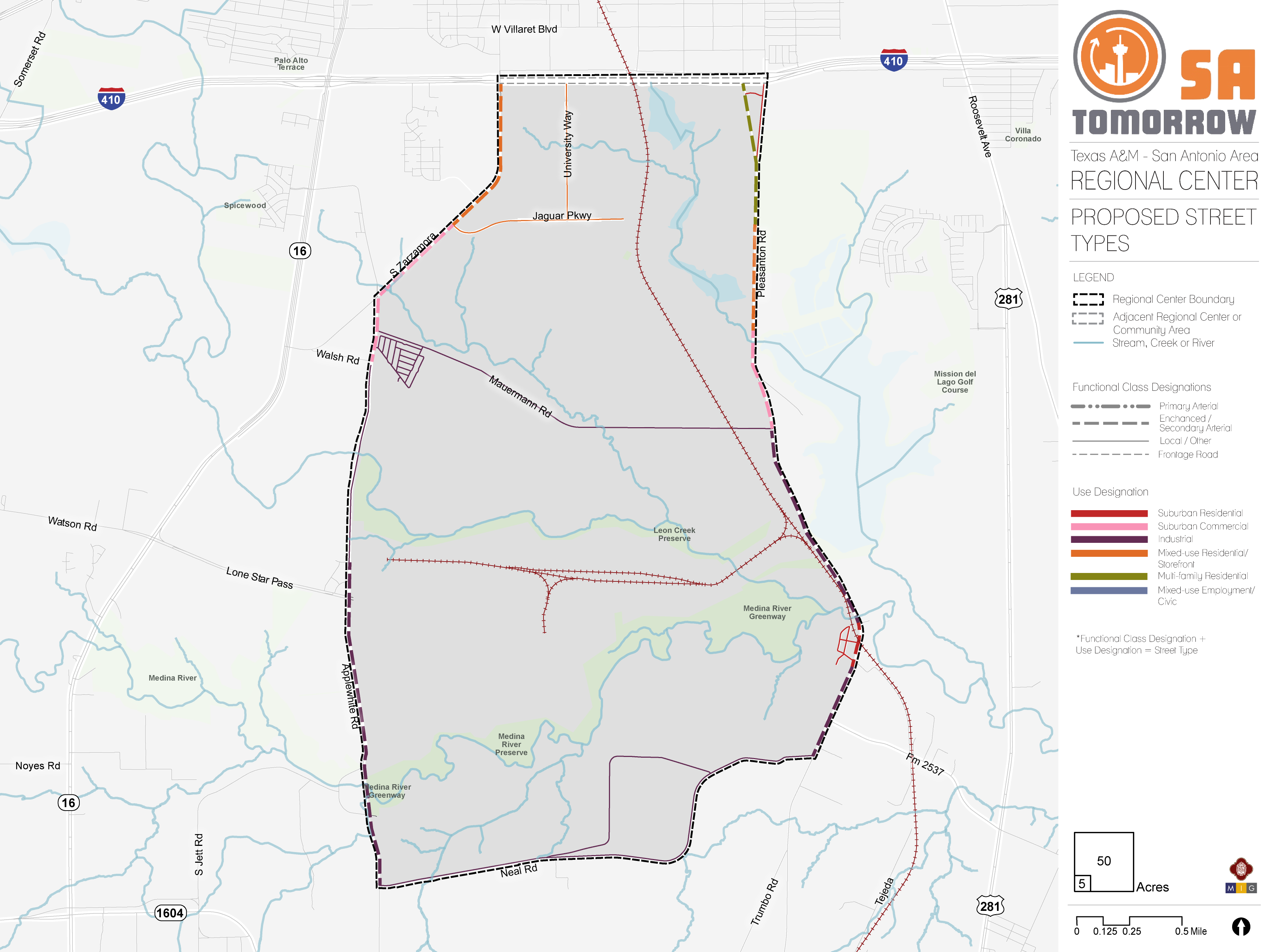
Balanced/Multimodal StreetsBalanced and multimodal streets, or “complete streets” are envisioned for the Texas A&M-San Antonio Area Regional Center, providing safe road designs for vehicles, pedestrians, and cyclists. South Zarzamora Street from Loop 410 to Jaguar Parkway is recommended for the Public Works Department to study for complete streets improvements. Also, all new connections and future streets within the master plan area of the Texas A&M University-San Antonio campus are envisioned as balanced/multimodal streets.
Priority Multi-Use TrailsKey Medina River Natural Area trail connections in the south of the Texas A&M-San Antonio Area Regional Center provide regional arteries of a separated pedestrian and bicycling infrastructure network, connecting numerous parks. The access points to these regional amenities provide opportunities to improve connections for people who walk or bicycle, through deliberate side paths or on-road infrastructure like crosswalks, sidewalks and bicycle facilities. New connections are envisioned along:
- Leon and Comanche Creeks from Medina River Natural Area trail to the Texas A&M University-San Antonio campus area; and;
- Comanche Creek from Mauermann Road to Hwy 16 Preferred Bicycle Routes
On the few roads that currently exist in the Regional Center, bicyclists can ride only in mixed-traffic on high-speed and high-volume roads. As new connections are built, incorporating bike infrastructure such as designated lanes is highly recommended. These measures will create safer and more comfortable riding conditions that encourage cycling for today’s commuters and future students by welcoming newer, less confident cyclists that are unaccustomed to riding alongside vehicles. The provision of bicycle parking and micro-mobility options at transit stops provides an important connection for people who want to access transit by bicycle and helps to address the ‘last mile’ challenge. Overall, this helps connect people from their destinations and transit.
Based on input from the Planning Team and other community stakeholders, the Regional Center plan identifies priority bicycle routes for the plan area along Zarzamora Street and Villaret Boulevard, providing a direct connection between Palo Alto College and Texas A&M University-San Antonio campuses.Corridors identified as balanced and multimodal complete corridors within the master plan area surrounding the Texas A&M University-San Antonio campus also incorporate bicycling infrastructure as a component of the design based on the context of the land use and the types of facilities needed.Recommendation #3
Manage future transportation demand through deliberate parking management strategies and traffic management plans that prioritize pedestrian, bicycle, and transit options during special events.The Texas A&M University-San Antonio campus is host to a growing number of special events that will place a heightened strain on the street network and create challenges for people who drive and use transit or shared mobility. This type of congestion requires strategies that encourage multi-modal choices and allow one-time or infrequent visitors to navigate transportation options and parking areas efficiently.
Special events traffic plan strategies for future events hosted by Texas A&M University-San Antonio should focus on improving the experience for those who use transit, shared mobility and micro-mobility, by accommodating special event priority lanes for bus traffic surges, or bus bulbs, to allow buses to pick up passengers without entering/exiting traffic. Specific plans to facilitate ease of use for shared mobility options and micro-mobility will help relieve stress on the transportation network during special events. Studies will need to be conducted to determine the appropriateness of each strategy for the areas of local congestion.
Parking management solutions include providing information on traffic conditions and parking availability at key locations, as well as utilizing guide signs to help visitors find their way to desired parking areas. Pricing strategies are also a solution as they generate revenue for parking spaces based on demand, and incentivize alternative transportation, if cost becomes a barrier to parking.
Recommendation #4
Consider freight movements and needs in land use and transportation planning activities.Freight trucks deliver many of the items needed for day-to-day life, but are often overlooked in planning for our communities. Freight delivery has been changing rapidly as more people buy products online that are delivered to homes by small freight trucks. As the development of new roads and parcels takes place, the needs of freight servicers need to be considered, including dedication of adequate travelling/turning/parking space for light and heavy freight trucks.
Recommendation #5
Support VIA Metropolitan Transit service by prioritizing transit supportive policies and infrastructure near transit stations.A future mobility hub is anticipated at the intersection of University Way and Jaguar Parkway. This intersection will require prioritized transit-supportive policies and infrastructure, such as reduced parking requirements, and a cohesive network of sidewalks, crosswalks, and curb ramps improvements to provide safe connections for people to access transit, whether by walking, bicycling, or getting dropped off in a vehicle.
Providing last mile connections between transit and micro-mobility options and key destinations, such as jobs and public spaces, improves mobility throughout the area while supporting walkability and safety for all transportation users. Key components of VIA Metropolitan Transit’s approach of making a place transit-supportive include creating streets designed for pedestrians, improving the safety of all users, and supporting compact, mixed-use developments that provide access to a variety of services reachable on foot.
Every person that gets on or off a bus or other transit vehicle is a pedestrian. Safe, comfortable, and direct access to transit for people who walk or bike to a transit station or stop will improve their experience as a transit rider and will increase the number of people who choose to walk, bicycle, or take transit as their preferred travel choice. These improvements also contribute to the overall quality of neighborhoods and communities.
Mobility Framework
The Mobility Framework lays out the vision for accommodating the constantly expanding mobility needs of the Texas A&M-San Antonio Area Regional Center. Below are the principles to ensure a mobility network that is safe and inviting for people who walk, shop, park and drive in the Regional Center.
Modal Priority Corridors
Streets play a multifaceted role in the plan area, serving as arteries for traffic, as public spaces, and to help connect adjacent communities with important area destinations and amenities. Recommended design changes to current and future streets can help achieve the community’s overarching vision for the Regional Center. Modal priority corridors do not exclude other users. They help guide design treatments and tradeoff decisions that support a particular mode during the design of a specific street.
AutomobileAutomobile corridors are envisioned to support high levels of daily motor vehicle travel. These corridors are often interstates, highways, arterials, and primary roadways which provide connections to major destinations and link the Regional Center to other plan areas. Significant automobile corridors in the Texas A&M-San Antonio Area Regional Center include Pleasanton Road, Neal Road, and S Zarzamora Road near the Texas A&M University-San Antonio campus.
BicyclesBicycle corridors are envisioned to provide convenient, safe, and comfortable biking options for all ages and abilities. An integrated network of bicycle routes along with a well-designed grid network of streets surrounding the Texas A&M University-San Antonio campus is a key aspect of the multimodal system. The mobility framework focuses on creating a complete bicycle network that provides direct access to the campus, commercial and residential nodes, and trails. Priority bicycle corridors in the Texas A&M-San Antonio Area Regional Center include Zarzamora Street and Villaret Boulevard, which provide a direct connection between Palo Alto College and the Texas A&M University-San Antonio campuses. Protected bicycle facilities are also prioritized along the newly proposed multimodal/balanced corridors throughout the plan area, to provide safe routes for students going to or from campus.
Multi-Use TrailnMulti-use trail corridors are envisioned to provide continuous arteries of separated pedestrian and bicycle facilities that connect numerous destinations, parks, retail and commercial development, schools, libraries, and residential areas. Multi-use trails provide access to regional amenities and improve connections for people who walk, stroll or bicycle. The Texas A&M-San Antonio Area Regional Center will benefit from the expansion of the existing Medina River Natural Area trail, to provide connections to Pleasanton Road Trailhead near Mitchell Lake. An additional multi-use trail connecting to the Medina River Natural Area trail will extend beyond Mauermann Road to the campus area. Another priority connection provides a link between Mauermann Road and Hwy 16.
Balanced/MultimodalBalanced and multimodal corridors are envisioned as “complete streets.” Complete streets are designed to enable safe access for all users and to accommodate all ages and abilities, including children, older adults, and persons with disabilities. These corridors balance the priorities of multiple modes and require additionalcommunity conversations and case-by-case design to best align with the community vision. The function of the road, level of traffic by mode, and adjacent land use and intensity will help determine the road type and design features. As the Texas A&M-San Antonio Area Regional Center continues to grow in terms of employees, residents and commercial services, this Regional Center will build upon the existing balanced/multimodal corridors of University Way and Jaguar Parkway to include Zarzamora Street, and the future gird network of new connections serving the campus area, the Vida! San Antonio development, and industrial areas in the central portion of the Regional Center between Mauermann Road and Leon Creek.
Pedestrian Focus AreasPedestrian focus areas refer to specific nodes that accommodate significant volumes of pedestrian activity. These focus areas aim to create high-quality street-level experiences to enhance the economic strength of commercial and mixed-use districts. These areas include wide sidewalks, safe and balanced intersections, ample crossing opportunities and design elements focused on keeping pedestrians safe. The Mobility Framework identified the existing and planned expansion of the Texas A&M University-San Antonio campus and the Vida San Antonio community as priority areas for pedestrian-focused design treatments.
Intersection / Crossing EnhancementsIntersection and crossing enhancements should be both intuitive and predictable for all users. Whether signalized or un-signalized, crossings where a high level of multimodal activity including pedestrians, bicyclists, and motor vehicles sharing space, should be prioritized. Intersection enhancements include lowering motor vehicle travel speeds and ensuring high pedestrian visibility. Priority intersection and crossing enhancement locations are identified where complex movements occur and potential conflicts between pedestrians, bicycles and drivers exist. The Texas A&M-San Antonio Area Regional Center has identified 15 crossing locations that need enhancements, including the intersections of the newly proposed multi-use trail at Mauermann Road and along Pleasanton Road.
Mobility HubsMobility hubs are envisioned as scalable nodes of mobility options, such as frequent transit, shared rides, bicycling and micro-mobility. These areas converge multimodal access and connectivity with adequate lighting, shelters, benches, real-time information, accessible sidewalks and pedestrian crossings. A mobility hub is identified at the intersection of Jaguar Parkway and University Way to serve both university students and residents of the Vida San Antonio community.
Gateway TreatmentsGateway treatments can be an essential component of successful urban design. Gateways signal a change in character and are often used as a place marker. They are highly visible signs or arches which can showcase public art, and help establish area branding. It is suggested that four gateways are added to distinguish the Texas A&M University-San Antonio campus. These locations include the intersection of Zarzamora Road and Loop 410; Zarzamora Road and Jaguar Parkway; University Way and Loop 410; and the intersection of two newly proposed automobile roadways, located west of Jaguar Parkway near the railroad.
Texas A&M-San Antonio Area Regional Center Street Types
As communities evolve and grow, so do the demands on the mobility system. The location and type of growth in an area or along a corridor help determine the demand on the transportation network and the viability of various transportation options. This interdependence makes it crucial to plan for transportation and land use together. Thus, streets are organized not only by role and function but also by the character and surrounding land use context.Land uses which encourage mixed-uses and higher density developments on major roadways will provide capacity for additional pedestrians, bicyclists, transit riders, cars, and freight delivery trucks of various sizes. The future land use also influences other factors, such as drop-off delivery zones, shared mobility hubs, and walkability. The map below shows the interactions between future land use and transportation plans. The street type classifications integrate transportation and land use, to guide context-sensitive mobility solutions.
Relationship between the Street and Buildings
Safe and vibrant streetscapes depend on how buildings integrate with surrounding sidewalks. Minimizing building setbacks, the distance between a building and the street, is crucial for creating a walkable environment. Buildings adjacent to the sidewalk directly connect pedestrians to destinations and create an enlivened urban space with opportunities to activate ground-floor uses and provide shopping or entertainment offerings.
Smaller setbacks are characteristic of Mixed-Use Local, or Urban/Suburban Local typologies, which prioritize pedestrian-oriented design. Meanwhile, larger setbacks that can accommodate front-end parking, are more characteristic of secondary arterials (whether suburban, industrial, mixed-use or urban). Primary arterials are designed to move vehicles and may require large setback minimums to accommodate additional parking.
Vehicle SpeedsA successful street hierarchy will align travel speeds with street usage and roadway function. While major regional roads may require higher speeds to accommodate heavy traffic flows, most smaller roadways serve lower volumes of vehicles. On these roadways, lower speeds ensure a safe environment for both vehicles and pedestrians/bicyclists.
Street typologies that focus on moving vehicles, such as Suburban Commercial, Residential, or Industrial Super and Primary Arterials, will feature higher speeds. However, typologies that focus on people and places, such as Mixed-use, Multi-family, Urban/Suburban Local Roads and Secondary Arterials, will feature lower speed limits to increase road safety for both people and vehicles.
ParkingParking is one option for providing access to work, retail, or entertainment. Drivers in search of parking create serious traffic and safety challenges. Incorporating other safe street design elements, such as buffering between bike and travel lanes, can create a safer on-street parking environment.
Street types that emphasize people and places, such as those in Mixed-use or Multi-family contexts will restrict the supply of parking overall, which allows for more active uses, denser environments, and connectivity for pedestrians and cyclists. Meanwhile, intermediary street typologies that support vehicles, as well as people and places, will likely offer some on-street parking, in addition to smaller on-site lots. Conversely, Suburban Contexts or Super and Primary Arterials may eliminate on-street parking altogether, in favor of large surface lots and structures.
Curb AccessA space between the curb and travel lanes provides an opportunity to serve many uses such as driveway access, bus lanes, cycle tracks, on-street parking, bicycle parking, drop-off delivery zones, or shared mobility hubs. This flexible zone can be converted based on demand and play a role in street activation. The design of the curb influences how cars and people enter and exit work, residential, and retail environments. In areas where traffic and turning movements increase the risk of accidents, implementation strategies will reduce conflicts between driveway traffic and pedestrians and improve roadway safety.
Suburban Commercial contexts and Super or Primary Arterials focus on the ease of ingress and egress for vehicles, while Mixed-use or Local street typologies focus on moving people and emphasize how vehicle access can coexist with safe, walkable environments.
Lane WidthLane width determines how cities can allocate space for vehicles, transit, freight, bikes, and on-street parking. Streets often contain dedicated space for bike lanes, parking, safety islands, and travel lanes. The lane width will vary based on the surrounding context and modal priority. For example, transit, freight, and emergency response vehicles require at least 11’ travel lanes.
Wider lane widths are designed to move vehicles in high-speed environments. For example, a Suburban Primary Arterial will be wide enough to efficiently move cars through residential and commercial environments, while Mixed-use Local or Suburban Local environments support narrow lanes to reduce crossing distances for pedestrians and to help promote slower driving speeds.