Plan Framework
Focus Areas
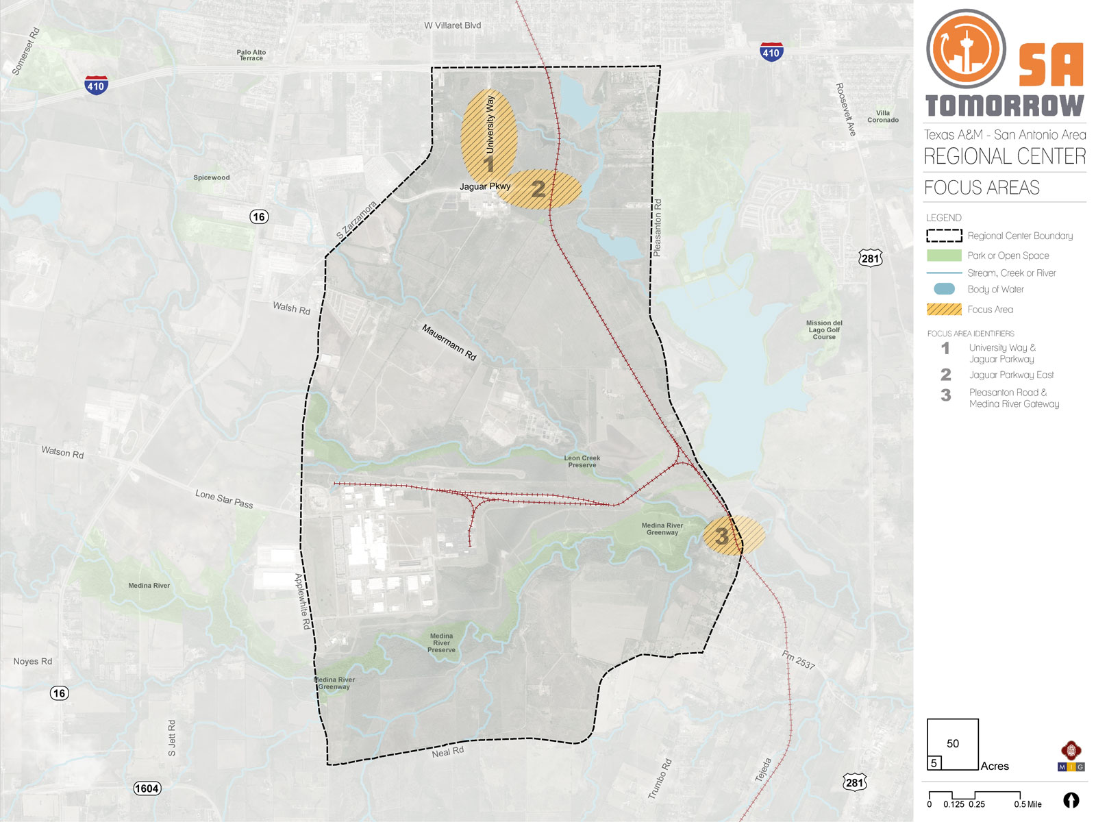
The map below highlights the Focus Areas identified for the Texas A&M San Antonio Area Regional Center Area. To learn more about each of the three focus areas, click on the animated targeted circle.
To provide specific feedback on the map, please click and drag a box on that location of the map and fill out the comment box. We would love to hear more from you!
You can also visit the bottom of the page to leave additional feedback.
Focus Areas have a strong combination of amenities and assets, where there is room for more people to live, work and play. Focus areas may also have, or be next to, sensitive places like historic areas, creeks, or traditional neighborhoods, where improvements and growth require careful planning. Each has a unique history, and will have a unique future. The plan provides extra focus on these places where there are opportunities to improve quality of life in ways that will be felt by multiple generations. Focus areas and mixed-use corridors are situated throughout the Texas A&M San Antonio Area Regional Center, so the opportunities they provide will not be far from anyone in the area.
Recommendation #1
Support the unique vision for each Focus Area by creating high-quality places with a mix of uses, vibrant public spaces, and appropriate transitions to surrounding uses and sensitive areas.- Current zoning and development regulations allow for mixed uses at a larger scale for phased or planned developments.
- Zoning districts and their accompanying development regulations that allow small to medium scale mixed-use projects should promote development that is consistent with the goals of having mixed-use, pedestrian friendly environments
- Ground floor retail uses will attract pedestrians with safe, efficient, and convenient crosswalks will allow for a safe pedestrian environment that will be welcoming to the community.
- Parking areas should be oriented to the interior of the adjacent development, so the buildings are the most visible from the Zocalo.
- The open space community area provided by the Zocalo will create a unique community space that is welcoming to all and will provide a signature gateway into the campus community. The success of the Vida Zocalo is dependent upon creating a lively environment by supporting an active streetscape through appropriate land uses.
Recommendation #2
Ensure Focus Areas and other area amenities can be easily and safely accessed and used by all modes of travel.- Main corridors and focus areas must provide a safe environment for all users with a strong focus on the pedestrian.
- Multi-modal transportation and transit ridership will benefit from increased pedestrian connectivity as all riders must be able to safely access the university and future development in the area.
- Protect existing trees and increase the amount of on-street landscaping and street trees to create a more pedestrian-friendly environment. Landscaping and trees provide shade and refuge from the extreme summer heat and will allow pedestrians to move more comfortably through the Texas A&M – San Antonio Area Regional Center, especially along Jaguar Parkway and University Way.
Recommendation #3
Balance future development in Focus Areas with natural features to enhance the area while protecting sensitive natural resources and ecological functions.- Minimize intensity of zoning along natural areas and trailheads and create transitions in densities to provide a range of housing options.
- Provide opportunities for future community spaces, trail networks, or existing open spaces accessible to the public.
- Use underutilized drainage ways, creeks, and utility easements to expand the greenway trail system in the Regional Center. There is currently a limited amount of green space recreational opportunities within the Texas A&M – San Antonio Area. Additional green spaces will become destinations for the community and surrounding areas, increasing overall activity within the Regional Center.
- Use Low Impact Development (LID) techniques and Green Stormwater Infrastructure (GSI) to improve water quality, reduce flooding, and create other community and environmental health benefits.
- Reduce the risks of flooding to lie and property by maintaining flood plains as natural areas.
Focus Area #1: University Way and Jaguar Parkway
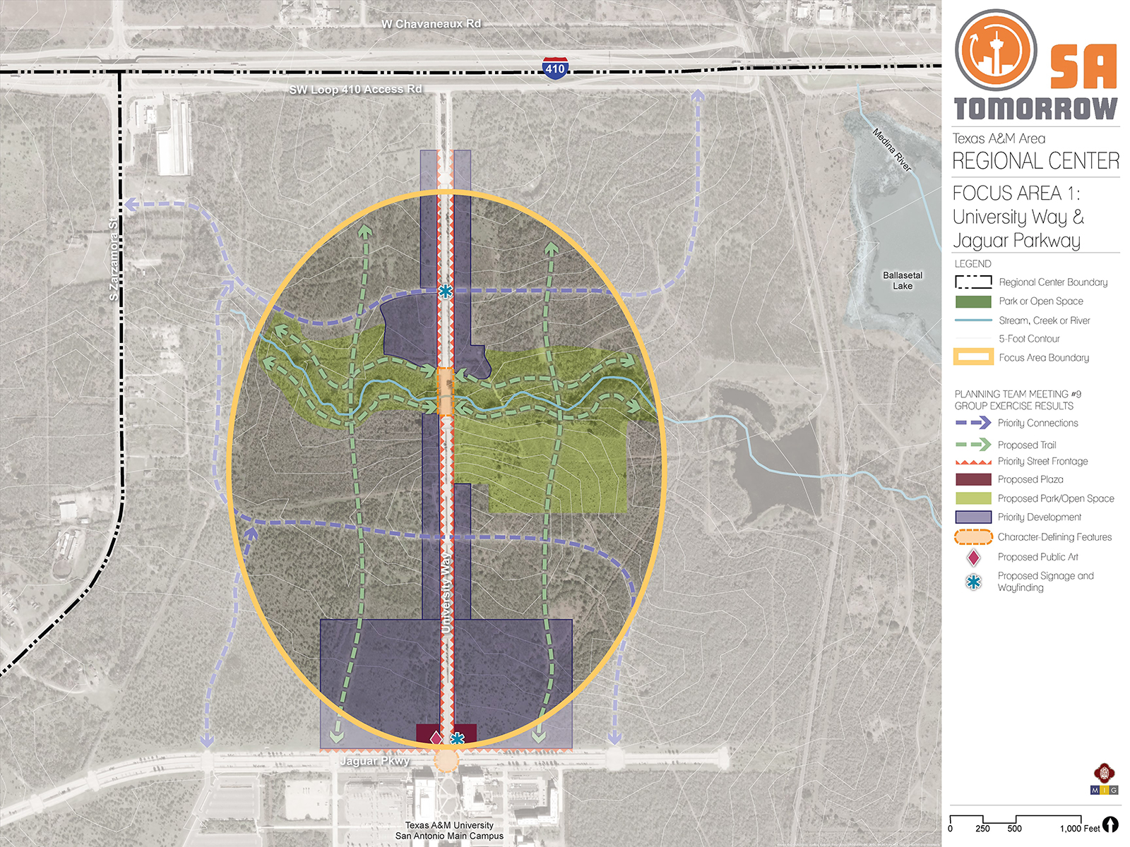
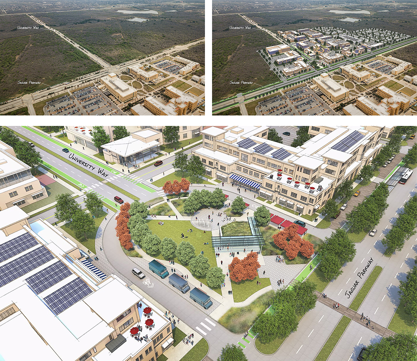
The first Focus Area that the Planning Team identified covers both sides of University Way from just south of Loop 410 to the intersection of Jaguar Parkway and University Way. A primary topic of discussion for Focus Area #1 has been the vacant property immediately north of campus, along University Way. The most recent development plan for the area is part of the Vida San Antonio project, which identifies the area as supporting a mix of housing options north of campus and a mixed-use town center immediately north of campus. The area is entirely vacant, and University Way is a highly traveled area, as it is the main entrance to the campus from Loop 410. Future development of the area could be a quality mixed-use corridor that provides a gateway to campus. The Planning Team also identified priority connections for streets and trials, that would connect the western half of the focus area with the eastern half.
VisionThe vision for Focus Area #1 is a welcoming and unique gateway to the University campus, with street-front mixed uses, including housing. The area will be accessible through all modes of travel and will also feature a focal place that encourages social gatherings.This focus area serves as the gateway to the Texas A&M University-San Antonio campus and it includes one of the main thoroughfares that will provide access to the Vida San Antonio Project. Echoing the University’s tower at the intersection of the Loop 410 frontage road and University Way, adding public art to the intersection of University Way and Jaguar Parkway helps create a defining character for the focus area and emphasizes the presence of the university and the Vida San Antonio project.
The University Way and Jaguar Parkway intersection is a main focal point in this Focus Area as it is the boundary were two large developments merge. Plans for development of this area include high density multi-family housing close to campus and transitioning to less intense uses further away from campus. Higher density housing closer to campus, with parking lots located on the interior of the developments, promotes walkability for the area. Incorporating plazas on each side of University Way will nicely tie into the main plaza entrance adjacent on the University campus. Wayfinding along this corridor and at a main entrance to the Vida San Antonio development incorporates another unique identifier for the Focus Area.
Connectivity is crucial to developing a successful mixed-use development. Providing a minimum of two main roadway access points to the Vida San Antonio project area along University Way will provide more opportunities for priority development along the University Way corridor that directs all activity, frontage and access to the corridor.
As the Vida San Antonio project develops, the rural nature of the area should be respected and incorporated into the development through trailways connecting to internal streets and proposed park and open space within the development. A flood plain area runs west to east, across the Focus Area. This unbuildable flood plain can be utilized as an open space, with possible trail connections across University Way. Trailways should be prioritized along the existing creek ways and floodplain and the trailway system should provide a direct connection to the University via Jaguar Parkway.
Transformative Project: University Way & Jaguar ParkwayThe vision for the University Way and Jaguar Parkway Transformative Project site is to create a vibrant, mixed-use area that will be the first phase in the development of the Vida San Antonio Project. This site is currently vacant and is envisioned to create a pedestrian friendly, accessible community that will meet the needs of the University’s anticipated growth. A key concept of the project is to develop dense multi-family residential, with some mixed-use components that provide small-scale retail options to the community. The overall goal of the project is to include first floor retail options that will activate the street and create a town-center environment. Buildings should be oriented to the street, and parking should be provided in the interior of the development to encourage pedestrian activity. The pedestrian element creates a value-added amenity to the area. The project area also would involve reconfiguring Jaguar Parkway to isolate the current intersection and transform the space into an exclusively pedestrian area that could serve as a community gathering space that would mirror the campus quad at the entrance of the University, referred to as the Zocalo. The Zocalo could host social gatherings, will provide a signature gateway to the campus, and serve as an open space that will interact with pedestrian activity from the adjacent Vida mixed-use development and the University campus, directly south.
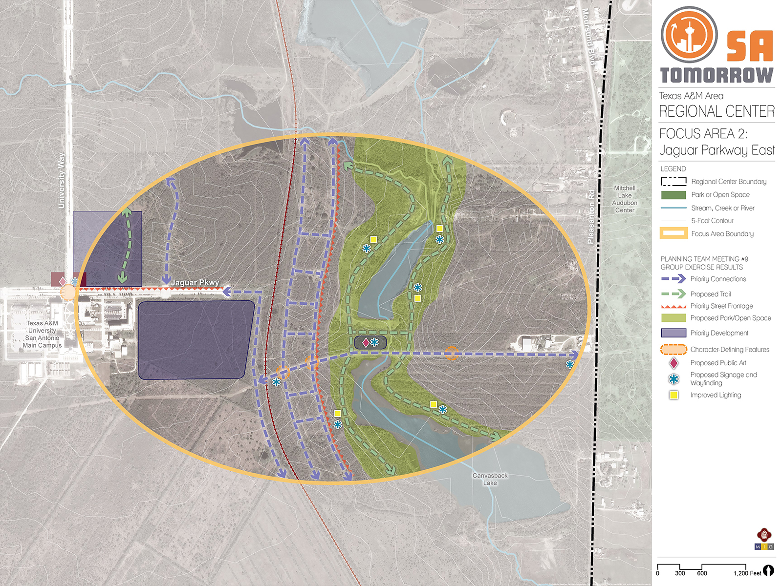
Focus Area #2: Jaguar Parkway East
Jaguar Parkway is a wide, five-lane road with additional on-street parking, bus, and bike lanes. The street begins at the intersection of Zarzamora Street and travels east, across campus, and intersects with University Way. The Focus Area #2 exists east of the intersection of University Way and Jaguar Parkway. Currently, Jaguar Parkway supports access to the residence halls but dead ends to the East. A priority for the area has been extending Jaguar Parkway across the railroad to the east. Although the area is mostly vacant, a floodplain, the railroad crossing, as well as an underground high-pressure gas line would make extending the road costly and has proven to be a determent to extending the road. The Planning Team discussed options to extend the road to the east, then south, and back to the east to propose an alternative solution.
Future development in this Focus Area could include the extension of Jaguar Parkway to Pleasanton Road, with amenities such as a park or open space, as well as trail connections, signage and lighting. Future development should consider the environmental sensitivity of Canvasback Lake, and provide a transition in density from the University. VisionFuture development in Focus Area #2 should prioritize a west to east connection from Jaguar Parkway to Pleasanton Road, and be considerate of the sensitive natural areas, including the floodplain to the east. The new connection would also create opportunity for park space and trail connectivity. Development in the area would be supportive of research and innovative types of industries, which is identified as a future goal within the Texas A&M University-San Antonio Campus Master Plan.Full development of this Focus Area will improve connectivity by providing direct connection to Pleasanton Road. As described, there are several hurdles to overcome in making this connection. However, if feasible, it should lead through low intensity development that is centered around the existing floodplain and Canvasback Lake. Providing trail connections within this area will create an extension for the desired regional trail system. Incorporating signage and wayfinding and improved lighting throughout the trailway will ensure safety for residents and visitors. Adding public art to the central connection point joining both sides of the lake and floodplain will enhance the character of the trail system and Focus Area. Compatible development should be prioritized at this central location and the western vacant lot adjacent to the university.
The University Way and Jaguar Parkway intersection is a main focal point in this Focus Area as it is the boundary were two large developments merge. Plans for development of this area include high density multi-family housing close to campus and transitioning to less intense uses further away from campus. Higher density housing closer to campus, with parking lots located on the interior of the developments, promotes walkability for the area. Incorporating plazas on each side of University Way will nicely tie into the main plaza entrance adjacent on the University campus. Wayfinding along this corridor and at a main entrance to the Vida San Antonio development incorporates another unique identifier for the Focus Area.
Connectivity is crucial to developing a successful mixed-use development. Providing a minimum of two main roadway access points to the Vida San Antonio project area along University Way will provide more opportunities for priority development along the University Way corridor that directs all activity, frontage and access to the corridor.
As the Vida San Antonio project develops, the rural nature of the area should be respected and incorporated into the development through trailways connecting to internal streets and proposed park and open space within the development. A flood plain area runs west to east, across the Focus Area. This unbuildable flood plain can be utilized as an open space, with possible trail connections across University Way. Trailways should be prioritized along the existing creek ways and floodplain and the trailway system should provide a direct connection to the University via Jaguar Parkway.
Transformative Project: Zarzamora Street and Loop 410 Underpass
The Zarzamora Street underpass of Loop 410 is the located in the northwest corner of the Regional Center plan area. The Planning Team identified the need for improved connectivity between Palo Alto College, northwest of the plan area, and the Texas A&M-San Antonio University campus. A gateway opportunity exists at this intersection that can provide a valuable pedestrian and bicycle connection between the two growing educational campuses. Suggested intersection improvements include:
- Expanded pedestrian islands in the middle of Zarzamora to create a safer crossing condition for pedestrian traffic
- Protected (either buffered or physically separated) bicycle lanes with defined crossings at intersections
- Trees and landscaping buffers to create a more comfortable environment for cyclists and pedestrians
- Explore opportunities to add lighting and gateway elements on the Loop 410 Underpass to make the area more inviting.
The improvements depicted in the diagram could be extended in both directions on Zarzamora Street in the future, and could also help guide construction of similar pedestrian and bicycle connections through the Regional Center, including the Vida San Antonio community, the University campus, and the Medina River Greenway to the south.
Focus Area #3: Pleasanton Road and Medina River Greenway Trail Connection
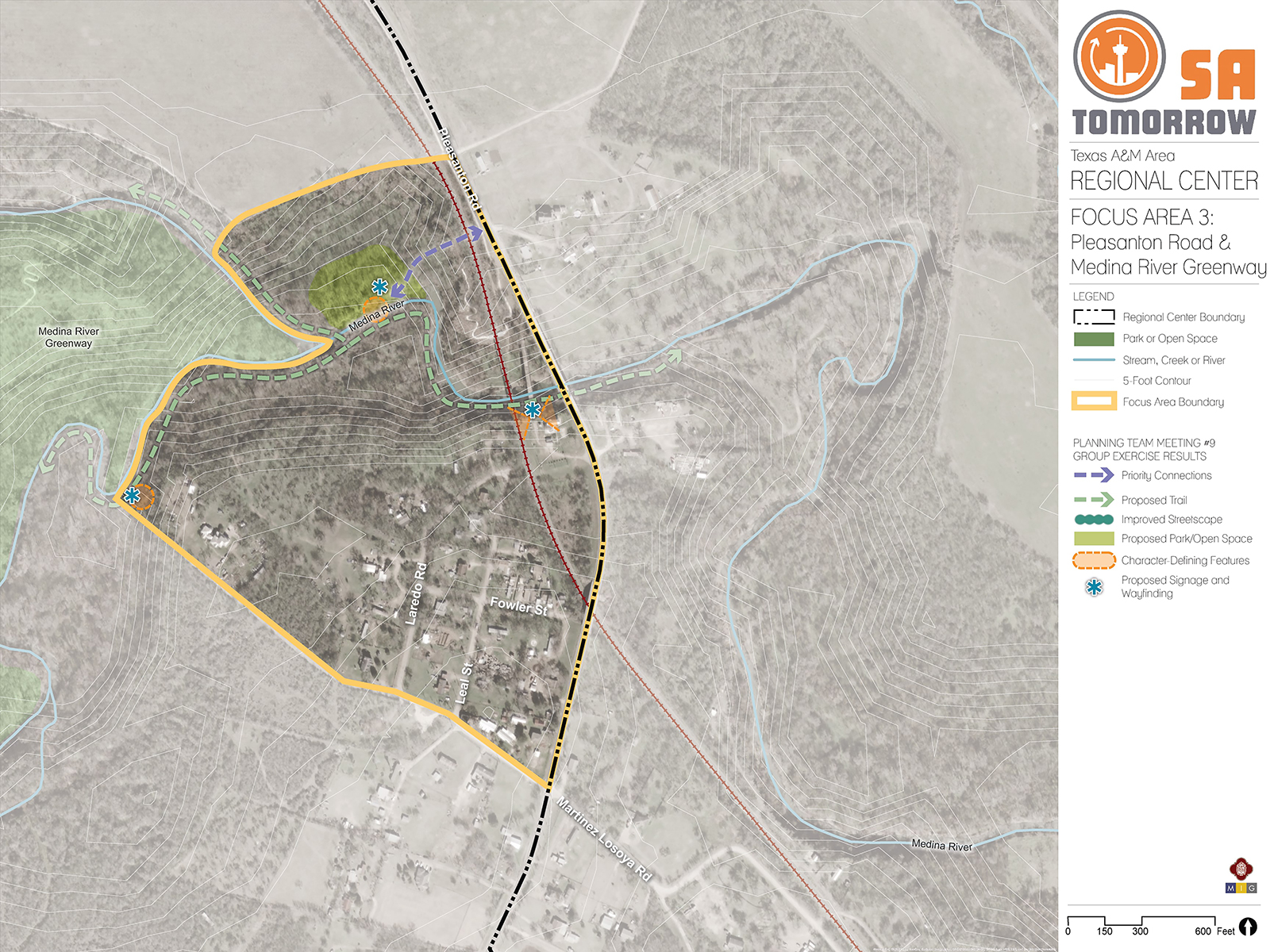
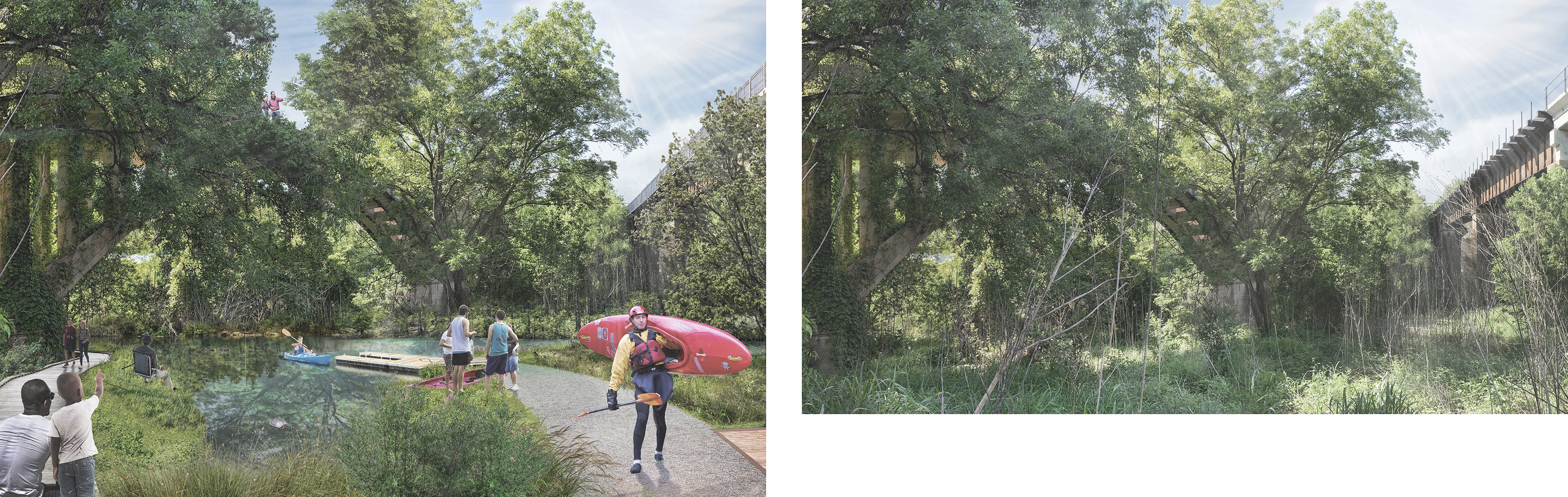
Focus Area #3 is where Pleasanton Road and the Medina River Greenway intersect (See Figure #9). The Focus Area could support a trail connection to Leon Creek, and currently there is project to enhance the trail. Future planning for the area could include character defining features such as artwork or murals. Recreational amenities such as kayak launch points, fishing areas, scenic overlooks or birdwatching blinds. Future planning or projects for the area should consider the value greenspace provides as a buffer from the heavy industrial uses from the Toyota Motor Manufacturing Plant to the south.
VisionThe vision for this area captures the community and Planning Team’s goal to preserve the rural character of the area and create a buffer from the industrial uses south of Mauermann Road, while providing unique amenities that make the area attractive for residents and visitors.This Focus Area is the most rural of the three focus areas, and that character should be preserved as the area develops. Building off the existing recreational infrastructure along the Medina River Greenway, proposed trail connections should be prioritized to provide another route of connectivity from the University to Pleasanton Road. There should be a direct connection from Pleasanton Road that leads to a park or open space, which serves as a trailhead, and connects to the trail system. The trail way should include character defining features unique to this Focus Area that ties in the existing historic bridge adjacent to the eastern boundary of the Focus Area.
Transformative Project: Old Pleasanton Road Bridge The old Pleasanton Road Bridge was constructed in 1910 and is one of the earliest documented concrete arch-style bridges in Texas. The bridge was bypassed by modern-day Pleasanton Road in 1985, and located within the Medina River Trailhead Focus Area. Although the bridge is currently not open to pedestrian activity, in the future it could serve as a unique landmark that would create a point of interest along the Medina River Greenway.Future improvements would require brush clearing and access from the Medina River Greenway into the riverbanks. Amenities for bird watchers, kayakers, and anglers such as bird blinds, kayak launch points, and fishing areas would create a unique attraction to the Greenway. The area would be accessible along the Medina River Greenway and future trail connections would provide access from the University and the areas to the north.
VisionThe vision for this area captures the community and Planning Team’s goal to preserve the rural character of the area and create a buffer from the industrial uses south of Mauermann Road, while providing unique amenities that make the area attractive for residents and visitors.
The Focus Area is the most rural of the three focus areas, and that character should be preserved as the area develops. Building off the existing recreational infrastructure along the Medina River Greenway, proposed trail connections should be prioritized to provide another route of connectivity from the University to Pleasanton Road. There should be a direct connection from Pleasanton Road that leads to a park or open space, which serves as a trailhead, and connects to the trail system. The trail way should include character defining features unique to this Focus Area that ties in the existing historic bridge adjacent to the eastern boundary of the Focus Area.